Monday, December 27, 2010

View from the Top

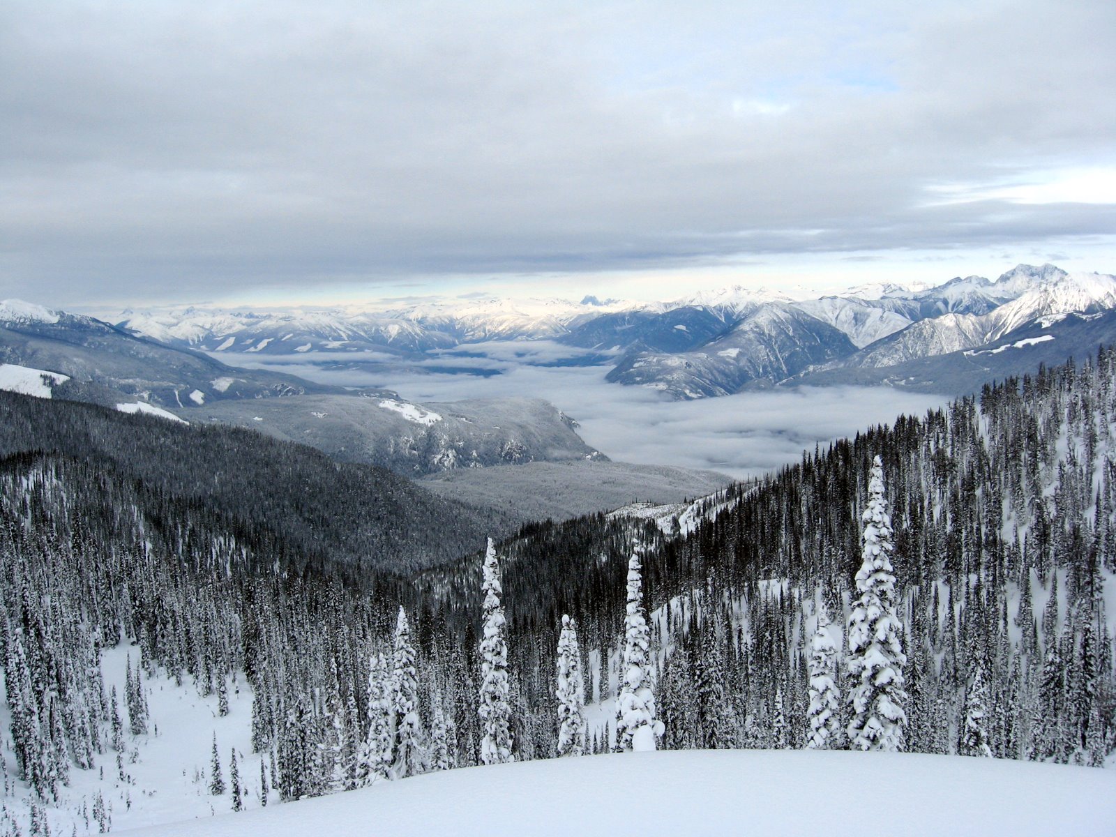
It's been a few days since I've found the time to blog, what with Christmas, walking, skiing, shoveling snow.... Even the usual nonsense that often is BC politics seems to have gone away for awhile. So nice.

A few days ago, though, a small group of us took the day to break a trail up to the Ski Club's cabin and get in a couple of runs at the same time. Snow conditions were surprisingly good right from the road (pretty much at Lake level) and got much better (and deeper) as we gained altitude. In fact, the snow got good enough that the usual 1-hour snowmobile trip took 2.5 hours, what with getting stuck and all. The hour-long ski to the cabin went well and we took two runs down the "North Bowl" before heading home. The picture is from the top of the North Bowl looking at low fog banks over the north end of Kootenay Lake and Duncan Lake. We could even see Howser Spire in the Bugaboos.

Snow conditions in the sub-alpine were OK - about 1.4 meters of snowpack, but more snow is needed - there were too many little trees and stuff to ski around, things which are usually buried. The weather word is to expect more snow tonight.

The trip down was slow as well and it was pitch dark before we arrived at the highway and the vehicles. Mind you, it's pretty dark here shortly after 4 pm....

Today we are experiencing what must be a Kootenay chinook. It's +5C and "almost" sunny. I'm busy chipping ice off the driveway so we can actually get the vehicles up the drive. That and a walk to deal with the post-Christmas stomach....

Tuesday, December 21, 2010

Reality Check: The Scale of Things

One of my FB friends posted this yesterday. If anyone out there is having trouble figuring out where we fit in the grand scheme of things, have a look.

Wednesday, December 08, 2010

Fatwas ... Canadian Style?

Full disclosure here: I haven't gone to Wikileaks to read all the latest gossip, but I have been following the story, sort of. My take on what we've learned? The Iraqi government is corrupt, some "world leaders" are on power trips and the USA thinks Canadian TV shows demonstrate a degree of anti-Americanism. Yawn.... When do we get stuff we "don't" know already?

So it was was with a certain degree of shock that I hear of a U of C professor calling for the assassination of Wikileaks founder Julian Assange. The good professor is a political scientist at the U of C and was Chief of Staff for Stephen Harper several years ago. He's been called a Conservative "strategist".

Even for a political strategist, I'd say this gaffe was poor strategy. It was certainly in poor taste and seems to have outraged many Canadians who, quite rightly, seem to believe such statements are...ummm...outrageous.

To Mr Flanagan's credit, he apologized the day after, but I wonder if that's good enough? Even if he was just trying to be funny, jokes of a certain kind are poorly tolerated these days - just recall offhand remarks made by some people on FB, jokes made in airports that security folks don't find funny....there are many examples. What surprises me is that even after so many such mis-steps by so many people...there seems to be a learning opportunity that's being missed here.

But the story doesn't end there. A Toronto woman sent a note to Flanagan to chastise him and, apparently, received the following response: "Better be careful, we know where you live". I think I'd be worried, and I hike in the woods where there are bears. Maybe if he'd added a smiley face?

So there you have it. A fatwa, Canadian style. When Iranian clerics issue fatwas, we might dismiss them as part of the lunatic fringe, but when they come from seemingly respectable Canadians with a public image, it's a bit harder to square with what we think we know about our country.

Thursday, November 18, 2010

Oh Yeah?

Maybe there was a time when some people might have found this offer too much to resist, but I can't say I've ever known anyone dumb enough. So the question is: why are these idiots still filling up people's inboxes with this crap?

An arab made a fixed deposit of $24,500.000.00 in my bank branch where am adirector and he died with his entire family in the war leaving behind no nextof kin. I want to present you as next of kin to claim the funds, get back to me if only interested for details as regards the transfer of this funds.

I shall require your full name, and telephone number to reach you. Most importantly, a confirmation of acceptance from you after which I shall furnish you with the fulldetails of this transaction Reply via this email only :lingyoung2@yahoo.com.hk
Yours Truly,
Ling Young.
lingyoung2@yahoo.com.hk
NOTE: REPLY TO MY PERSONAL EMAIL ONLY IF INTERESTED :lingyoung2@yahoo.com.hk

Tuesday, November 16, 2010

Saying Goodbye to Fall

The past few weeks have been that in-between season. Not generally nice enough for real hiking and no snow for skiing. Leaves have been gradually disappearing, although the apple trees in our yard still have their leaves. In fact, some haven't even turned color yet. We really haven't had a frost; I think zero was our coldest temperature early one morning.

We have been doing some walking. This view looks down Kootenay Lake on a day that really seemed more like a warm spring day than late fall. We were walking the Cedar Creek trail near Ainsworth on one of the few nice days we've had recently.

Things on the estate are ready for winter. Garden tools put away, wood all under cover, garden tilled, mulch and compost spread around. Snow has been forecast for later this week. So far, though, all we've noticed is the snow level dropping down closer and closer to our location. We hear of snow east of the Rockies, storms even. Big wind storms on the Pacific coast cutting power to thousands of people. Not much here, though. I'm predicting it will be December before we get freezing weather. Perhaps I'll be proved wrong this week.

Friday, October 29, 2010

Potash - A Strategic Resource?

The recent news out of Saskatchewan is the hostile takeover bid for Sask Potash by the Australian mining giant BHP.

There are a couple of ways of looking at this: let the market decide or have some level of government quash the proposed sale. The former might be in the interests of current shareholders - if there is a good offer, these shareholders could stand to make a substantial profit selling their shares to BHP. The latter really goes against both Federal and Provincial Governments' supposed free market philosophy, but could be justified by declaring this industry a strategic resource - too important to allow it to be sold.

In a somewhat surprising, but understandable, move, the Sask Government has come out against the sale, declaring it not to be in the interests of Canada or Saskatchewan. Given who else has come out against this proposed sale, the Feds will probably come out against it as well.

This is as it should be. There is no perceived benefit to the Province or the country by this sale. This is simply the quickest way BHP can enter the potash business. There have been far too many examples in Canada of valuable companies, good companies, being taken over and run into the ground, broken up or controlled by outside interests. Some industries are too important to allow the "free market" to do whatever the profit motive dictates. Not everything is about money!

Sunday, October 17, 2010

We're From the Government....

Let me get this straight: The Harper Conservatives feel driven to scrap the mandatory long-form census because they received complaints from: a) over 1000 people a day, or b) at least a few people in total, or... c) some other reason entirely. They feel compelled to protect us from fines and jail time because we might object to confiding information like how many bathrooms are in our house?

Give me a break.

This Harper (minority) Government scrapped Income Trusts in the mistaken belief that millions of tax dollars were leaking away and they have sidestepped climate change action, to name just two issues they've been on the wrong side of. They've followed a specific course of action despite often massive protests and opposition, and, in many cases, the facts.

They're not scrapping the long-form census because a few people have their shorts in knots over the questions. Rather, it's just another example of how this government is entirely driven by (mean-spirited, short-sighted, conservative) ideology and nothing else.

Saturday, October 09, 2010

Apple Harvest

What you see here is probably 10% of our entire apple harvest. One of 2 Jonagold apples and a very few on two other trees. This year was pretty much a disaster for our apple crop, although the trees are very young and quite small, so I shouldn't expect too much just yet. We had an infestation of various insect pests early in the season and I think that's what did them in. That and the unseasonably cool weather when fruit should have been setting. Oh well. There's always next year.

The apple was very good, by the way.

Saturday, October 02, 2010

Exploring the Koots - 1001 - Plaid Lake

With the fine fall weather hanging around the Koots for a few days, we headed off to explore the trail to Plaid Lake in the hopes of finding more larches in fall color, and, of course, the views.

This being a "rest day" we caught the 8:10 ferry across the Lake, found the right FSR leading up behind Crawford Bay and headed up. The FSR had been partially deactivated which, around here, means big drainage trenches in the road, making a high clearance 4x4 vehicle pretty much the only way to negotiate the holes. In addition to being full of deep trenches, it was steep, so the old truck started to complain near the top. Interestingly, the highest part of the access road was the best, but we walked that bit.
The trail in to Plaid Lake was fine, although the trailhead is higher than the Lake. When we got to the trail downhill to the Lake, I was surprised when Catherine suggested we head up to a nearby ridge for the views rather than hike down to the lake. I guess she's arrived at that stage when she'd rather stand on top of a peak rather than sit by a lake. Who knew?

At the "pass" we were just below Mt Crawford, a prominent peak visible east of Crawford Bay. It's one I'll have to come back to scramble up on another trip.

A short traverse across a steep slope and we were on a minor ridge with views in all directions of the compass. It's always fun to identify all these other peaks, including ones you've been on recently. After some time snacking and resting in the sun, it was back down and off to home. We were surprised by the amount of traffic waiting for the ferry and luckily happened to be almost the last vehicle that made it on for the trip across the Lake.

Thursday, September 30, 2010

Exploring the Koots 0930 - Fletcher Lake and Beyond

Not long after getting home from the Macbeth Trail, and while still restoring my carbohydrate and water balance, I got a call about a hike the next day. The plan was to head to Upper Fletcher Lake (which I've been to before) but to then traverse the Fletcher Basin, climb up to the next ridge and possibly attempt Mt Trafalgar. With blue skies and the promise of fall larches, it was the matter of a few minutes to re-load the pack, make a new lunch and get ready for another day in the hills.

The first challenge was the Fletcher Creek FSR which was getting some attention from the grader. This was probably a good example of something that gets worse before it gets better. Good thing we had high clearance vehicles.
The hike in to Upper Fletcher is quick - only slightly more than an hour, with fall larch color appearing in the woods as we approached the ridge overlooking the Lake. We descended into the valley, crossed through the woods and climbed up to the next ridge, made our way along that ridge and finally emerged to see Mt Trafalgar still quite a ways off. Too far for this day's trip.

We enjoyed the views, the blue skies and tried to identify peaks in the distance before heading back to the trailhead. Just another day in Paradise.

Wednesday, September 29, 2010

On the Ice Again - Macbeth Glacier Revisited

The original plan for the day was for Stu and I to drive up the Glacier Creek FSR and have a look at the Horseshoe Glacier, just across the valley from Jumbo Pass. From the map, it seems like there would be a number of peaks that could be climbed from this glacier, a possibility for next summer perhaps.

The day didn't unfold as we had planned. Forestry was busy replacing bridges on the Glacier Creek road and at Km 30 they had big machines digging holes in preparation for a new bridge. To salvage the day, we decided to head up to the Macbeth Glacier, partly to look at the trail conditions, partly to have a walk around on the glacier and partly because Stu hadn't been up to that area yet.

We discovered only about a dozen trees down across the trail and we only had time for a short walk around on the glacier, but the day was stellar with not a cloud to be seen. We also saw a small bear track in the path on the way up. Hope the bear enjoyed the blueberries that were along the trail. We found the berries a bit past their "best before" date so we left most of them for the bears.

Tuesday, September 14, 2010

On the Trail of Earl Grey - Sept 9 to 13, 2010

The Earl Grey Trail is a historic route connecting the Toby Creek valley near Invermere with the Hamill Creek Valley near the NE end of Kootenay Lake. It's about 60 km in length, crosses the Purcell Range over Earl Grey Pass and is normally hiked in about 5 days. Word had spread that the trail was in good condition this year so 10 of us decided to give it a try. Four of the group drove vehicles to the Toby Creek trailhead and started there while six of us started at the Hamill Creek side.

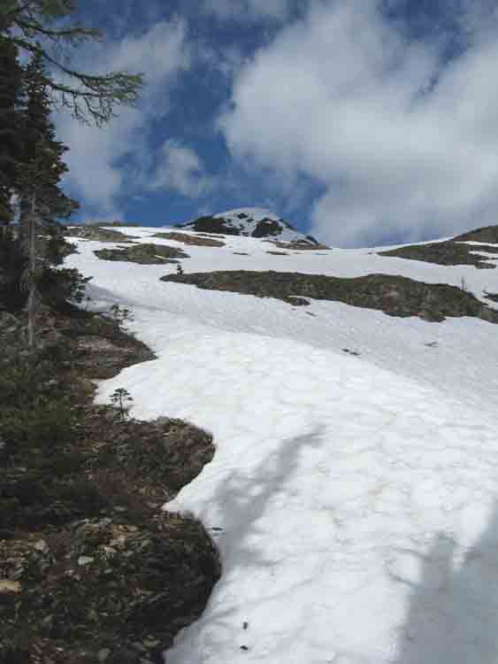
Information about this trail comes with cautions about changing mountain weather, tricky creek crossings, real backcountry camping, long distances from help, precautions about bears and food storage, steep trails and so on. For the most part, I'd say the route lived up to that information.

Our first 3 days were relatively easy, with 12 km being the longest day of hiking. Distance hiked is only one way to measure difficulty, though, and we found the going slow, with huge logs to clamber over and around, slippery log crossings of many streams, several (5) cable car crossings, muddy sections of trail and wet West Kootenay bushes. Indeed, the entire trail over the 5 days was damp or wet. There were showers, intermittent rain and cool temperatures. Only a couple of brief times did we see the sun.

Camp spots were small and rustic and we spent a certain amount of time at the end of each day drying boots and clothing. Food had to be pulled up into trees in case bears visited our camp during the night. Biffies were the usual backcountry rustic.

The first 3 days were spent hiking up Hamill Creek mostly in old growth cedar forest. It was dark, damp and mystical. Misty too, sometimes. Day 4 we climbed for several hours to reach Earl Grey Pass and admired what views we could with the swirling cloud and mist. The trail then dropped steeply into the Toby Creek Valley. We believe views in this area would be quite amazing, but we saw only low-hanging cloud and mist. We made an impromptu camp in a thick spruce forest where we were able to find some dry areas under the trees to camp for the night. All that remained was a 4-hour hike to the end of trail and the drive home.

This is a challenging trip through remote terrain. Trail conditions were good but rough. Careful preparation is important, keeping in mind changeable mountain weather. The unprepared could find themselves in trouble quite quickly. That said, it's a classic hike through the very remote Purcell Wilderness and well worth doing. Hope for good weather. Pictures live here.

Sunday, September 05, 2010

Things that go Bump in the Night

It wasn't a bump, really, but the scream of the smoke detectors that woke us up at about 1:30 am last night. You know how it is - first you think it's the phone, then the iPod, and the noise is loud enough to almost blast you out of bed before you realize what it is.

Once the brain is able to focus on the issue, you realize that there is no smoke. In fact, with the windows and doors open to the night breezes, there is nothing but the night air wafting through the house, night air and the smell of skunk.

We've had the skunk smell on occasion. No big issue - we get bears, raccoons, the odd mountain lion... we live in the woods so all that is pretty normal. I spent the next 15 minutes looking for what could have set off the smoke alarms. No place in the house was left unexplored. Nothing was found. Nothing but that skunk smell.

So now the question is: can skunk fragrance set off smoke alarms? I did find one serious discussion on the web about this and the conclusion seemed to be "maybe", but "maybe not". A coincidence, or....?

Friday, September 03, 2010

Exploring the Koots - 0902 - Dennis Basin

The past two times I've been to Alps Alturas, my eye has been drawn to some high grassy ridges just across the valley. This area is, I learned later, Dennis Basin and that was the little explore for Thursday.

The access is up the Wilson Creek East FSR in the same direction as Alps Alturas, but turning off earlier and taking a surprisingly good trail up to the sub-alpine. There had been a frost during the night so bushes were icy and wet, but soon the meadows were reached where numerous options presented themselves in the form of several grassy ridges heading off in different directions. A bit late in the season for alpine flowers, but nice meadows.

Our wandering took us to one ridge with great views across the valley to Alps Alturas and a range of peaks with new snow dusting the higher elevations. The skies were blue and the air was clear so we were able to pick out peaks in all directions: mountains in the Valhalla Wilderness area, Kokanee Glacier, Idaho Peak, Carlyle, Texas Peak, Mt Reco, Brennan, Loki, Whitewater, London Ridge and many others.

We then hiked up another steep hill to the highest point around for more views and a leisurely lunch before heading back down and to the trail home.

Wednesday, August 25, 2010

Backcountry Exploring - T&B 2010

The past 4 days have been spent with 4 friends on what Gerald calls his "Thrash & Bash", annual explorations of new, backcountry areas in the Kootenays where access is difficult, terrain is challenging and other people are completely non-existent. This year's T&B met those criteria in spades. Last year's trip was reported here.

Armed with food, gear, big packs and a hand-drawn map showing possible elk trails into the chosen area, we set off for the end of the road, about 50 km up the Howser Creek FSR. The weather forecast was for "showers" and cool temperatures. Not bad for hiking, we thought. Sure enough, it started showering soon after we started walking, but a better description would be intermittent "rain".

There was a trail to start with and this trail did appear occasionally throughout the hike, but when we lost it, as happened a few times, we had to resort to alder bashing and rhodo thrashing until the trail reappeared. After 5.5 hours of this, we reached a little valley with a good location for a campground. By then, of course, it was raining and we were completely soaked. Hypothermia was a concern as the only thing that had been keeping us warm was the hiking. Once we stopped, we were freezing.

Tents were set up, a tarp was hung from the trees, everyone changed into "dry" clothes and headed into their respective tents. A fire was eventually started, the rain stopped for awhile and we began the process of drying out.

Monday morning was cool and cloudy, so after warming up, we headed up one valley to see what we could see. We eventually arrived at the toe of a small glacier. Temperature was +3C at mid-day. Back at camp, 3 of the group decided to hike up to another pass while 2 of us kept the fire going and worked on drying things out.

Tuesday, all of us hiked to a small glacier and high ridge east of a prominent peak (The Virgin), where we had fantastic views of peaks in all directions and the Bugaboo spires just to the NW of us. Had we been a little bit higher, we probably could have seen the ACC's Kain Hut. Skies were blue, temperatures were warming, our clothes and boots were less wet than they had been since we started. What more could one ask for?

Wednesday, we packed up to hike out. The problem with elk trails is that they seemed to disappear occasionally, leaving us thrashing around in the bush trying to locate the trail again. This happened repeatedly, but we finally, after 5 hours of this kind of fun, returned to our vehicles for the 2 hour drive back home. I think I can safely say that everyone was pretty thrashed after this little explore into another little pocket of the West Kootenay wilderness.

Saturday, August 21, 2010

The ACC's 55+ Camp at Fairy Meadows

I just got back from working at the ACC's 55+ Camp at Fairy Meadows - August 15-20. For those who don't know, Fairy Meadows is both an area and a hut (actually, it's officially called the Bill Putnam Hut) located in the Adamant Range of the Selkirk Mtns up at the beginning of the Swan Creek drainage from the Granite Glacier NW of Golden, northwest of Kinbasket Lake (the Columbia River). It has been possible to hike in to this area in the past and I have tried that about 12 or so years ago with a friend from Saskatoon. At that time, it really was one of those "hikes from hell", the hike out only being better because it was downhill.

This last trip was about as different as it could get. We met the helicopter at Bush Harbour, about 43 km up the east side of the Lake, and in a 10-minute ride were flown across the Lake and up Swan Creek to the meadows above the hut with our gear and enough food to feed a small army for a week. The small army in this case was a guide and 7 clients with myself as chief organizer, assistant and cook.

The area is used mainly as a winter ski destination but summer mountaineering is also excellent, with many peaks, glaciers to travel on and fantastic scenery. All from the comfort of a great hut- 9 of us in a hut that fits 20. And, as an added bonus, it's not in a National or Provincial Park so there are none of those hoops to hop through.

Our days began early, we climbed up and down many meters of elevation, hiked across parts of the Gothic and Granite glaciers, climbed Sentinel Peak, Mt Unicorn and the ridge near Houdini's Needle and finally, on Friday, were all whisked back down to the Lake in two flights and a total of 30 minutes. This particular trip provided new experiences in mountaineering for many of the participants although a few were more "old hands" at this sort of thing. Regardless of the level of experience, being able to spend some time in such amazing surroundings with like-minded, friendly people made for an excellent week.


Friday, August 13, 2010

Exploring the Koots - 0812 - Mt Willet

A few days ago Stu and I had made plans to "do" Mt Willet on Thursday. This double peaked mountain is one of the "Big 3" in this area and all 3 are over 9000 ft elevation. Two other fellows we know well decided to join us for the day's excursion and so, accordingly, we all met at 6 am to make the drive to the trailhead.

Mt Willet is across and up the Lake so the drive takes one north and around the end of the Lake and past the small settlement of Argenta and from there up another logging road (Salisbury FSR?) for 11 km. We were at the trailhead and ready to hike just before 8 am.

The trail goes through woods and up a narrow valley, steeply up and over another ridge and through still another valley to the SE ridge of Willet.

Alpine flowers were excellent and numerous stops were made to take pictures and debate what floral specimen we were looking at. Numerous nice camping sports as well presented themselves along the way. If only the approach wasn't so steep, I'd be more inclined to go there and camp for a few days...

We were 2 hours to the foot of the ascent ridge and another 1.5 hrs to the summit. Unfortunately, the forecasted sunny, clear day was cloudy and smoky with a cool breeze from the north. We thought the smoke was from fires in the Cariboo, way off to the NW. Consequently, views weren't very good and pictures of those views were even worse. Conditions didn't encourage us to lounge around on the summit, so after inhaling some food, we headed down, taking a detour to Heart Lake (more uphill and downhill) before heading back to the vehicle.

Friday, August 06, 2010

Exploring the Koots - 0804 to 0805 - Silverspray to Woodbury Traverse

Stu and I had a "nice little hike" over the past 2 days, something both of us have been thinking about for awhile now: the Silverspray to Woodbury traverse.

Sipverspray and Woodbury are two alpine or sub-alpine cabins in Kokanee Glacier Provincial Park's eastern regions. The idea is to hike to one cabin, then route-find your way to the other cabin, crossing several ridges and several deep valleys, all filled with anything from small to huge granite boulders.

It was a short traverse for us - about 4.5 hours cabin to cabin (not including the hike in to Silverspray and the hike out from Woodbury), but the way was pretty easy to figure out. The route was generally rough and steep, but nothing too unusual for the Kootenays. Despite some potential weather concerns, the two days were stellar so we were able to enjoy the scenery along the way. And all within a 20 km drive from home....

Sunday, August 01, 2010

Making Sense of the Census Furor

The long-form census form is a real issue???? I think the Harper Cons are just diverting attention away from things like the G20 fiasco, the failed RCMP Commissioner, or .... whatever.

This blog puts the funny spin on the Harper Cons tactics, and that's probably about all their tactics are worth....

So how many Canadians have served jail time for refusing to complete this census form?? Zero!

How many complaints have been made about this intrusive form?? Very few.

Is this really all the Harper Cons have to talk about and all they have the guts to deal with?

Thursday, July 29, 2010

Exploring the Koots - 0729 - Mt Carlyle

A few days ago, while hiking to Texas Peak and Paddy's Peak, we had good views of Mt Carlyle. Actually, Mt Carlyle can be seen to the west from Kaslo with it's quite prominent twin peaks easily visible. It was decided that today would be a good day to tackle the peak so 3 of us met at Dan's place at 7 am.

First was the 2-hour vehicle access part of the trip, which involved driving towards New Denver, up to the historical mining town of Sandon and from there up the Carpenter Creek Road.

A few km up that track things became sufficiently overgrown that we switched to the mountain bikes. This went fine until we ran into significant avalanche debris, probably deposited 2 winters ago. After carting our bikes over a few piles of this, we abandoned the bikes and walked.

The track eventually led towards a low point on Mt Carlyle's SW flank where there had been mining activity over 100 years ago. Remains of old buildings and other mining debris still litter the scene here.

Past this col, the route followed Mt Carlyle's south side until the SE ridge was reached and from there it was merely a scramble over large, blocky granite to the summit.

Although light showers had accompanied us this far, we were treated to clearing skies and warmer temperatures once we reached the summit, and views improved accordingly. Ridges and familiar peaks were in all directions, including Kokanee Glacier Park to our south.

After enjoying the views and our lunch, we retraced our steps, taking some time to explore the old mine site. Distant thunder didn't materialize into anything and the truck was finally reached after about 6.5 hours of hiking. About a 10-hour day all in all.

Sunday, July 25, 2010

A Week of Ups and Downs

A whole week of climbing up hills and down hills. The only way I really train....

I attended the ACC Saskatchewan Section's mountaineering camp where a few of us introduced relative beginners to the techniques of general mountaineering: glacier travel, scrambling, ropes, knots, route-finding, etc.

There were 21 of us at the camp and each morning we were up at 4 or 5 am so we could have our climb done before it got too hot later in the day. We were also trying to avoid soft, mushy snow as well. Our weather was mixed: we got chased off one ridge by a small thunder storm, two days were sunny and hot and the last day was showery and cool.

No sooner was I back home then I ran into one of my skiing friends and learned that they were heading to Jackson Basin the next day. Sounded like a chance to see some flowers and get some more exercise, so Catherine and I went along with the group.

The ridge at the south end of Jackson Basin is good for alpine flowers and the views were stellar in all directions - the Valhallas, the Purcells, Kokanee Glacier, and peaks closer to home as well. We all hiked up Texas Peak, a minor scramble at the end of the ridge. There was enough time after that peak to tackle another, and the next one on the ridge was Paddy's Peak, so off we went.

Paddy's Peak was a bit more difficult - big blocks of rock that made 2-handed scrambling and climbing necessary, and a narrow ridge with airy positions on both sides in places.

To get back to where Catherine had waited after completing Texas Peak, I had to climb yet another high point on the ridge and by this time, my legs were starting to feel the need for some rest. One thing you can say for the hills in the Kootenays is that they are steep.

Once back at the truck, it remained only to head back home for BBQed burgers and beers and that well-needed rest.

Wednesday, July 14, 2010

The Aging Process - Some Questions Answered

I was being amused the other day by following a FB exchange between a couple of former students of mine. The complaints revolved around sore backs, tired this and worn out that, and these kids are, well, just kids really. Youngsters. Still with lots of memory and drive, one would think. And they haven't passed the big four oh yet. So much to look forward to....

Not having finished the 6th decade myself just yet, I can't claim to be a complete expert on the subject, but I thought it worthwhile to share some insight into what's just over the horizon for these young whippersnappers in the belief that forewarned is forearmed. Or something like that. So, in no particular order....

The first thing I noticed happened many years ago, probably shortly after I turned 25. I realized that I wasn't able to stay up and party all night and head out on a long road trip the next day with a hangover. This was reinforced a few years later when I had a several-hour flight back home after significant party. Never again, I promised myself, and it was a promise I think I've managed to keep ever since. Life is tooooo short to feel that crappy.

Your eyesight will start to change, probably necessitating bi or tri-focals. With the new graduated lenses, you won't look like an old fogie, but YOU will notice. You may not be able to read with your glasses on, close work may be difficult, especially in low light situations. Personally, I have a large magnifier light at my workbench and it gets lots of use. You will also find that you can't stand bright sunshine without "shades" and a hat. Never used to bother me, but now....?

Your hearing acuity will likely decrease, especially if you're a male. This has both benefits and disadvantages which I will leave for you to discover.

You may find that you can't sleep as well. In fact, you may find yourself awake for 2 or 3 hours each night, this after falling asleep exhausted in the middle of a good book at 9 pm. Did I mention that late nights will probably become impossible? I've been known to nod off at any time after 8:30 pm. Is this the outcome of a low-stress lifestyle? Who knows, but my iPod gets much late-night use and I'm often awake, for the day, at 4 or 5 am. Sigh.

A related sleep issue seems to be connected to bathroom breaks, usually several of them, interspersed throughout the night. Your only solution seems to be semi-dehydration, otherwise, you kidneys have waaaay too much to do. If I'm at a backcountry hut or a hostel, I have to insist on a lower bunk near the door to facilitate my late-night excursions.

I've always been a list-maker, that being the only technique guaranteeing I'd be able to remember what jobs needed to be done. Develop this technique, because you will start to think you've lost your mind as you get older. That's probably slowly becoming true. The number of times I've gone to another part of the house (or to town) and been unable to recall why I was there.... Lists are the solution. Keep a clipboard handy. It's true what they say: "the mind goes first...".

You will develop more and more aches and pains, not all of them caused by your kids/spouse/job/government. Get used to it. Warm up gradually each day. Don't just charge off wildly into your work. Get a family doctor and make sure you find one who doesn't have a problem prescribing non-steroidal anti-inflammatory drugs. I can supply a list on request. Convince yourself that the saying "Better living through Chemistry" is really true. Make sure your medical plan covers physiotherapist's services. Find a doctor and a physio who aren't going to tell you that just because you're over 45/50/55 that you have to scale back your activities to match your age. With all your other "issues", you don't need condescension to add to your humiliation.

Speaking of medical issues, if you're a guy, there will be age-related "tests" that your doctor will want to perform. Tests you never dreamed of when you were younger. Tests I won't mention here but will leave to your imagination. If you're a gal, you probably won't have much sympathy for guys on this one.

Well, that's a start. I can revisit this topic occasionally, as there are issues I haven't even touched yet, like lowered metabolic rate (meaning you can't eat as much as you'd like unless blimp is a word you want applied to your shape), sex drive (meh), ambition (who cares) and a possibility that you will start to like country music (arrrrgh). I haven't taken up golf, or shuffleboard, or cards, but I suppose I shouldn't rule them out, yet.


Thursday, July 08, 2010

Exploring the Koots - 0708 - Mt Brennan Revisited

Almost a year ago, I had my first climb of Mt Brennan, one of the major peaks in this area. This year there were no grizzly tracks on the summit, but just in case, I brought reinforcements.

We're at the start of a minor heat wave this week. When you'e having daily highs of +34C, what better time to go climb a mountain. We did decide to leave early with the idea of getting some of the uphill done before the sun so Catherine and I picked up Stu at 5:30 am and were hiking by 6:15 am. We managed the first 600 meters of elevation gain to Lyle lakes before we were in full sun.

Once we left Lyle Lakes, the climb was mostly on moderate to steep firm snow slopes, definitely my preferred conditions for climbs like this one. A clear sky, that minor heat wave I mentioned and snow everywhere made for furnace-like temperatures, but we were on the summit before lunch. Time to take in some food, liquids and the views in all directions and it was time to start bouncing down the snow slopes and down the trail to the trail head.

Wednesday, June 30, 2010

Exploring the Koots - 0630 - Mt Schroeder

Had a call from another hiking/skiing friend from town wanting to know if I was interested in climbing Mt Schroeder today. Decisions like these are always so difficult.....

Bringing Catherine along just so she could experience the joys of Kootenay bushwhacking, we picked up Osa at 6 am and by 7 am had driven up the Schroeder Creek FSR and arrived at where we figured the hiking should begin. No trail up this mountain either, so it was another couple of hours slowly working our way up a steep ridge, climbing over fallen logs, pushing through alder, Devil's Club and rhododendron bushes. Finally we gained more open ground and only had a few moderate snow slopes and a brief scramble to the summit. Familiar peaks were visible in all directions.

Not really wanting to go downhill through all that brush, we decided to try an alternate route down some very steep snow slopes to a valley bottom that was very close to a logging road. Some of the going was tricky, but we only had a brief battle with the forest before we emerged on the road only a few km from the truck. We were home by mid-afternoon.

Some pictures are available at the end of the "Spring & Summer 2010" web album.

Monday, June 28, 2010

Exploring the Koots - 0627 - Mt Kaslo

Yesterday was a day to experience the best in West Kootenay bushwhacking as four of us set out to climb Mt Kaslo.

This is a moderate peak right across the lake from the town of the same name and my hiking partner and I have been looking at it for some time now, considering when we ought to go see what the summit was like.

As it turned out, there were 4 of us along to catch the 6:30 am ferry from Balfour to the east side of Kootenay Lake. By 8 am we had driven north up the Lake and east along another old logging road and were ready to start thrashing through the bush.

To make a long bushwhack story short, it took 7 hours of that kind of travel to get to the summit and back, each with our own personal cloud of mosquitoes following in our wakes. There is no trail up this mountain, so the strategy was to head off through the trees in the general direction. It's a pretty thick forest so views were pretty limited until we neared the top.

Views from the summit, though, were as to be expected - Mt Loki to the south, Powder Creek to the east, Kootenay Lake below us and mountains in all directions. After a rest and some sustenance, we began the thrash back down. It was shorter, but no more fun than the ascent. We just missed one ferry so had to console ourselves with ice-cream cones while waiting for the next boat to take us across the lake.

Tuesday, June 22, 2010

Given the Circumstances, What Else Can You Do?

With the oil "leak" in the Gulf continuing with no end in sight, irony (or possibly sarcasm) may be the only forms of humour suitable. Check out Wimp.com.

And that word? It's "Regulations". Apparently not a term Republicans were familiar with.


Monday, June 21, 2010

Exploring the Koots - 0620 - Krao Lake Revisited

Yesterday Stu and I hiked up to Krao Lake, a small body of water high above Ainsworth with a great view of Kootenay Lake. I'd been there a couple of times before, but we needed something relatively short and more suited for "training". And we were interested to know how much snow was still on the ground up high. Krao Lake is at about 6500 ft.

On the way up, we noticed how poor the road conditions were. This is a Forest Service Road and is being used by active logging, so that in itself wasn't so unusual, but it's also the access to Cody Caves Provincial Park. We weren't sure how many tourists would be able to visit the park given how rough the road was. I heard later that the Park will not likely open this year because of changes to Parks fees, road conditions and the like. Mostly to do with neglect on the part of our wonderful Provincial Government. Sigh.

Not far along from the trailhead, we were on snow, and by the time we arrived at the lake, there must have been at least 1.5 meters of the stuff on the ground. It was firm and easy walking, fortunately.

We picked a safe gully and climbed up to a peak above the lake to see the views. Sitting in the sun with Kootenay Lake below and mountain peaks in all directions makes one feel very fortunate to live in such a beautiful place.

Thursday, June 17, 2010

Better Late Than Never, I Suppose

The final report into the Air India mess was released today. Heck, it's only been a quarter of a century since it happened. So what have we learned?

Our National Security Forces (CSIS and the RCMP) bungled their investigation and weren't working together well enough to deal with information they had before the event. Not much has changed since then, apparently. Obviously, turf wars are more important than the safety of the public.

Airport and airline security is still missing the mark, as it was then.

What's likely to happen? Well, the report's 3000 pages will certainly be sitting on some dusty shelf in Ottawa. I can't imagine that any Canadian government will have the guts to deal with CSIS or the RCMP. It's also more likely that the traveling public will be subjected to more nonsense like removing their shoes and not being allowed to take baby bottles and small containers of water on board. Oh, and no toothpaste either and don't forget the total body scans. There, that should make everyone feel safer.

Friday, June 11, 2010

The G20 Boys - Increasingly Out of Touch

This is a picture of a real lake. It's a lake in BC, one of thousands and thousands in the province. Pretty lakes, impressive lakes. And although BC may be "The Best Place on Earth", even it doesn't have a monopoly on nice lakes. Canada is full of them. And check out the green stuff at the edge of the lake. That's real grass, not Astroturf.

So why, in all that's holy, does our federal "government" feel the need to spend any amount of money to create a fake lake surrounded by Astroturf in downtown Toronto, or whatever part of the center of the universe the G20 clowns are meeting in? I realize there is very little "nature" left in southern Ontario, but a fake lake, using taxpayers' money??? Have these goofs completely lost their marbles?

The so-called leaders of the G20 represent countries and governments that have accumulated massive national debts and generally mismanaged things so badly that the world's economy is closer to meltdown than we want to imagine. Hosting this bunch at our expense and supporting the media circus that seems to go with such meetings, with a security cost exceeding $1 billion? Words almost fail me.

Fortunately I have just enough words left to remind everyone that this is a minority government that simply just doesn't "get it". They don't seem to understand the term "fiscal prudence", they don't understand environmental issues or human rights concerns. This G20 spending debacle is simply the latest in a string of disasters from Harper and his gang. It's time for them to go.

Sunday, June 06, 2010

On the Gold Rush Trail

We just finished a short trip further west in BC, exploring some of the early Gold Rush Trail. The main objective was to get to Lillooet and do some exploring around that area. And since the weather at home didn't seem to be shaping up to be very summer-like, we decided to head out.

Our first stop was just north of Rock Creek in a nice BC Provincial Park with a campsite right on Rock Creek. This is one of the Trans Canada Trail access points, so we did a bit of walking and trying to figure out what birds were chirping in the trees. One nice thing about camping at this time of year (and in mid-week) is that the campgrounds are still pretty empty.

The next day we made it through Kelowna and on to Merritt. We've been past Merritt many times, but we couldn't recall ever actually going through the town, and our route took us through Merritt and on to Spence's Bridge. We camped for the night just south of there at another nice BC Provincial Park Campground. Part of our entertainment was watching the CP and CN trains roll up and down the canyon just below the campground. There was also a short hike that followed an old gold rush trail dating back to the late 1800s.

The next day we were on to Lytton, where the Fraser and Thompson Rivers join, and on to Lillooet, former home of "Ma" Murray and staging point for some of the Cariboo Gold Rush.

Lillooet wasn't all that interesting, although it has a nice setting, located on the Fraser River, nestled down between some pretty imposing peaks. This is one of the hottest places in Canada, and you could see why.

We spent a few hours driving over the Duffy Lake Road to Pemberton, which seemed much like a junior version of Canmore or Banff or something - all new condos and little shops. Exploring this didn't take much time so we headed back to a nice Forest Service campground on Cayoosh Creek.

The next day we spent some time in Lillooet, then headed north and east to Cache Creek, on to Kamloops and towards Vernon.

En route, we stopped briefly at the old farm that Catherine's parents once owned, continuing on to a quiet place on the Shuswap River for the night.

Our last few hours before getting home was spent going over Monashee Pass, taking a look at Edgewater, wandering around the lakeshore promenades and botanical gardens in Nakusp and New Denver, before completing the last short drive back to the hacienda.

Monday, May 31, 2010

Exploring the Koots - 0530 - Hamill Creek

Sunday was hiking day and 4 of us arranged to meet up with another 4 to hike a short distance up Hamill Creek.

The trail up Hamill Creek is actually the Earl Grey Trail, a 60 km track from Argenta at the north end of Kootenay Lake, up Hamill Creek to Earl Grey Pass and down Toby Creek. You eventually come out in the East Kootenays near the Panorama ski development. This is a real wilderness trail with cable car river crossings, rough trail and the usual expectations of wild animals. The suggested hiking schedule for this trip would be about 5 days.


The trail was named after a former Governor General of Canada who crossed the pass in the early 1900s. Apparently he was looking for a spectacular trip and this is what he was introduced to. It's now completely in the Purcell Wilderness Conservation Area.

Somewhat before the mid-1900s, the lower Hamill Creek valley was the location of some mining exploration. Some equipment remains there still. I understand that this was also an early example of a mining scam, with hopeful investors from NYC funding a several-year project in this area. Their original route into the river valley was right up the lower canyon which is difficult enough that the present trail completely avoids this area, descending to the river from the small settlement of Argenta.

Our trip on Sunday went as far as the second cable car crossing of Hamill Creek. Rain was intermittent most of the afternoon, but quite steady as we drove to the trailhead. Four of our hiking companions were delayed by the rain, apparently enjoying warm soup at a home near the trailhead so we didn't meet them until quite late in the afternoon, on our way back to the parking lot.


At the second cable car crossing was also an old log cabin, gradually mouldering away. After a brief examination of the cabin, we turned for home.


Tuesday, May 25, 2010

Exploring the Koots - 0524 - Gerrard

Highway 31 heads north-west after leaving the north end of Kootenay Lake and follows the Lardeau River to Trout Lake. After that, it becomes more like a logging road....but that's another story.

Monday, on a bit of an impulse, I decided to wander up to Trout Lake and camp for the night. There is an old BC Forest Service site at the east end of the lake, more or less where the old townsite of Gerrard used to be. Very few signs of the old townsite remain. I understand the town was named after a banker, but I decided I wouldn't let that bother me too much....

These days, it's a good place to go fish or to watch fish - there's even a fish-watching platform on the banks of the Lardeau River.

We've gone up there to watch Bald Eagles while they've been fishing and have counted literally dozens of the great birds feeding.

This trip there were no fish and no Bald Eagles, just a solitary Rufus hummingbird who came to check out the tail lights on the camper.

Last night it was about views of the lake and the sunset. I've heard a certain amount of whining about the poor sunsets here in the mountains: "...just not like a prairie sky...", which kind of figures, given where we live. However, the sun went down last night almost right up at the end of the Lake and I thought the evening sky was pretty good - for the mountains, that is ;-)


Sunday, May 23, 2010

Keeping up with the Hummers

We've been visited by hordes of hummingbirds the past couple of weeks, and despite having the feeders just outside the windows, they have proven to be difficult photographic subjects. I've tried shooting through the window, tried the camera on a tripod outside using a remote camera release and I'm still not happy with the results.

We figure that with the cool weather we've been having, the Hummingbirds aren't finding much other food. Some species spend their summers in the high alpine, but that part of the world is still covered with snow. So, for the time being, they've taken up residence in the trees not far from our two feeders.

We get 3 species of these little birds here: the Rufus, the Calliope and the Black-Chinned. It's been a source of endless amusement to watch their antics around the feeder. There are times when there are nearly a dozen hovering around, stacked up like jetliners waiting to land at La Guardia International.

With this cold weather, the flock is emptying each feeder nearly every day, but they still seem to have the energy to put on their mating displays. Some things are just too important to put off, no matter what the weather.

Wednesday, May 19, 2010

East Kootenay Wanderings

We spent a few days at the end of last week wandering around some of the East Kootenays. This is an area that we often drive through, but seldom stop to explore. This time, in conjunction with a Library Federation meeting that Catherine had to attend, some new areas were visited.

This is the valley with Cranbrook at the south end and Golden at the north end. The Kootenay River comes in from the east at Canal Flats and heads south and the Columbia River originates, also at Canal Flats, and heads north. The second picture is of the "mighty" Columbia River, just north of Columbia Lake, near Fairmont.

One area we found excellent for bird-watching was a hill just north of Wilmer overlooking the Columbia Wetlands Conservation Area. We saw several new species there

We also spent a short time hiking to the top of the hoodoos near Fairmont. Nice views from the top of the cliffs.

One night was spent at Alces Lake (Latin for Moose Lake), which is in Whiteswan Provincial Park, about 22 km up a Forest Service Road east of Canal Flats. The lake was cute and the campground was just what you'd expect of a BC Provincial Park campground - nice sites, excellent trees...

One luxury was a soak in Lussier Hot Springs, a couple of natural, undeveloped pools on the western boundary of Whiteswan PP. This was the early morning soak so as to miss the crowds later in the day. Nothing like the smell of hydrogen sulfide and hot water!!

The next night was spent at Lake Enid Rec Area - a BC Forest Service Site only a few km from Wilmer (near Invermere). A resident loon and several pairs of Red-Throated Grebes added to the ambiance of the lake with the Rockies in the background. Unfortunately, our peaceful evening was disturbed by some Albertans (have I mentioned that this valley is Calgary's playground?) arriving at 10 pm, unloading their dirt bikes, ATVs and chain saws and feeling the need to start up each one of their toys and make noise at 11 pm. Fortunately, they didn't stay up too late.

The next night, we tried a Forest Service Road (FSR) west of Canal Flats along the Findlay Creek. Findlay Falls was interesting and the Forest Service campground was very nice. Quiet and peaceful with the sounds of the Findlay Creek in the background.

The last day, as we were heading home, we rode our bikes a short distance through Bummer's Flats, an area along the Kootenay River just north of Ft Steele. Mainly we were looking for birds, but there was a cool, spring smell to the air and the ride was a nice diversion to our trip.

Further along the road home, we spent an hour or so wandering around the Creston Wetlands looking for new bird species.

After this, we had only the drive north along the east side of Kootenay Lake to the ferry and home.