Thursday, September 30, 2010

Exploring the Koots 0930 - Fletcher Lake and Beyond

Not long after getting home from the Macbeth Trail, and while still restoring my carbohydrate and water balance, I got a call about a hike the next day. The plan was to head to Upper Fletcher Lake (which I've been to before) but to then traverse the Fletcher Basin, climb up to the next ridge and possibly attempt Mt Trafalgar. With blue skies and the promise of fall larches, it was the matter of a few minutes to re-load the pack, make a new lunch and get ready for another day in the hills.

The first challenge was the Fletcher Creek FSR which was getting some attention from the grader. This was probably a good example of something that gets worse before it gets better. Good thing we had high clearance vehicles.
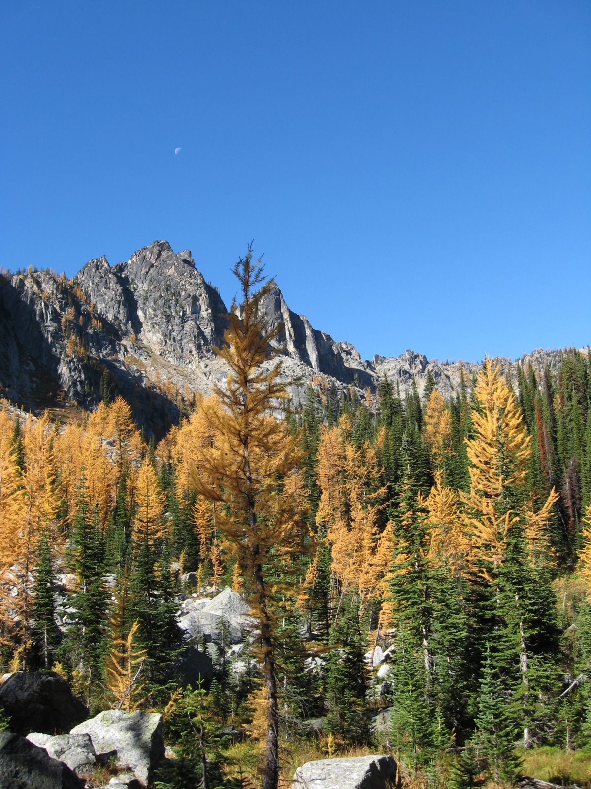
The hike in to Upper Fletcher is quick - only slightly more than an hour, with fall larch color appearing in the woods as we approached the ridge overlooking the Lake. We descended into the valley, crossed through the woods and climbed up to the next ridge, made our way along that ridge and finally emerged to see Mt Trafalgar still quite a ways off. Too far for this day's trip.

We enjoyed the views, the blue skies and tried to identify peaks in the distance before heading back to the trailhead. Just another day in Paradise.

Wednesday, September 29, 2010

On the Ice Again - Macbeth Glacier Revisited

The original plan for the day was for Stu and I to drive up the Glacier Creek FSR and have a look at the Horseshoe Glacier, just across the valley from Jumbo Pass. From the map, it seems like there would be a number of peaks that could be climbed from this glacier, a possibility for next summer perhaps.

The day didn't unfold as we had planned. Forestry was busy replacing bridges on the Glacier Creek road and at Km 30 they had big machines digging holes in preparation for a new bridge. To salvage the day, we decided to head up to the Macbeth Glacier, partly to look at the trail conditions, partly to have a walk around on the glacier and partly because Stu hadn't been up to that area yet.

We discovered only about a dozen trees down across the trail and we only had time for a short walk around on the glacier, but the day was stellar with not a cloud to be seen. We also saw a small bear track in the path on the way up. Hope the bear enjoyed the blueberries that were along the trail. We found the berries a bit past their "best before" date so we left most of them for the bears.

Tuesday, September 14, 2010

On the Trail of Earl Grey - Sept 9 to 13, 2010

The Earl Grey Trail is a historic route connecting the Toby Creek valley near Invermere with the Hamill Creek Valley near the NE end of Kootenay Lake. It's about 60 km in length, crosses the Purcell Range over Earl Grey Pass and is normally hiked in about 5 days. Word had spread that the trail was in good condition this year so 10 of us decided to give it a try. Four of the group drove vehicles to the Toby Creek trailhead and started there while six of us started at the Hamill Creek side.

Information about this trail comes with cautions about changing mountain weather, tricky creek crossings, real backcountry camping, long distances from help, precautions about bears and food storage, steep trails and so on. For the most part, I'd say the route lived up to that information.

Our first 3 days were relatively easy, with 12 km being the longest day of hiking. Distance hiked is only one way to measure difficulty, though, and we found the going slow, with huge logs to clamber over and around, slippery log crossings of many streams, several (5) cable car crossings, muddy sections of trail and wet West Kootenay bushes. Indeed, the entire trail over the 5 days was damp or wet. There were showers, intermittent rain and cool temperatures. Only a couple of brief times did we see the sun.

Camp spots were small and rustic and we spent a certain amount of time at the end of each day drying boots and clothing. Food had to be pulled up into trees in case bears visited our camp during the night. Biffies were the usual backcountry rustic.

The first 3 days were spent hiking up Hamill Creek mostly in old growth cedar forest. It was dark, damp and mystical. Misty too, sometimes. Day 4 we climbed for several hours to reach Earl Grey Pass and admired what views we could with the swirling cloud and mist. The trail then dropped steeply into the Toby Creek Valley. We believe views in this area would be quite amazing, but we saw only low-hanging cloud and mist. We made an impromptu camp in a thick spruce forest where we were able to find some dry areas under the trees to camp for the night. All that remained was a 4-hour hike to the end of trail and the drive home.

This is a challenging trip through remote terrain. Trail conditions were good but rough. Careful preparation is important, keeping in mind changeable mountain weather. The unprepared could find themselves in trouble quite quickly. That said, it's a classic hike through the very remote Purcell Wilderness and well worth doing. Hope for good weather. Pictures live here.

Sunday, September 05, 2010

Things that go Bump in the Night

It wasn't a bump, really, but the scream of the smoke detectors that woke us up at about 1:30 am last night. You know how it is - first you think it's the phone, then the iPod, and the noise is loud enough to almost blast you out of bed before you realize what it is.

Once the brain is able to focus on the issue, you realize that there is no smoke. In fact, with the windows and doors open to the night breezes, there is nothing but the night air wafting through the house, night air and the smell of skunk.

We've had the skunk smell on occasion. No big issue - we get bears, raccoons, the odd mountain lion... we live in the woods so all that is pretty normal. I spent the next 15 minutes looking for what could have set off the smoke alarms. No place in the house was left unexplored. Nothing was found. Nothing but that skunk smell.

So now the question is: can skunk fragrance set off smoke alarms? I did find one serious discussion on the web about this and the conclusion seemed to be "maybe", but "maybe not". A coincidence, or....?

Friday, September 03, 2010

Exploring the Koots - 0902 - Dennis Basin

The past two times I've been to Alps Alturas, my eye has been drawn to some high grassy ridges just across the valley. This area is, I learned later, Dennis Basin and that was the little explore for Thursday.

The access is up the Wilson Creek East FSR in the same direction as Alps Alturas, but turning off earlier and taking a surprisingly good trail up to the sub-alpine. There had been a frost during the night so bushes were icy and wet, but soon the meadows were reached where numerous options presented themselves in the form of several grassy ridges heading off in different directions. A bit late in the season for alpine flowers, but nice meadows.

Our wandering took us to one ridge with great views across the valley to Alps Alturas and a range of peaks with new snow dusting the higher elevations. The skies were blue and the air was clear so we were able to pick out peaks in all directions: mountains in the Valhalla Wilderness area, Kokanee Glacier, Idaho Peak, Carlyle, Texas Peak, Mt Reco, Brennan, Loki, Whitewater, London Ridge and many others.

We then hiked up another steep hill to the highest point around for more views and a leisurely lunch before heading back down and to the trail home.