 We've been picking raspberries from the garden for the past week and today we drove up a nearby logging road to see if there were any huckleberries. What we found were ripe and plump. After the lousy spring/early summer weather we were wondering if there would be any berries this year, but it appears it will be worth exploring for some in another week or so.
Friday, July 29, 2011
It's Berry Season
We've been picking raspberries from the garden for the past week and today we drove up a nearby logging road to see if there were any huckleberries. What we found were ripe and plump. After the lousy spring/early summer weather we were wondering if there would be any berries this year, but it appears it will be worth exploring for some in another week or so.
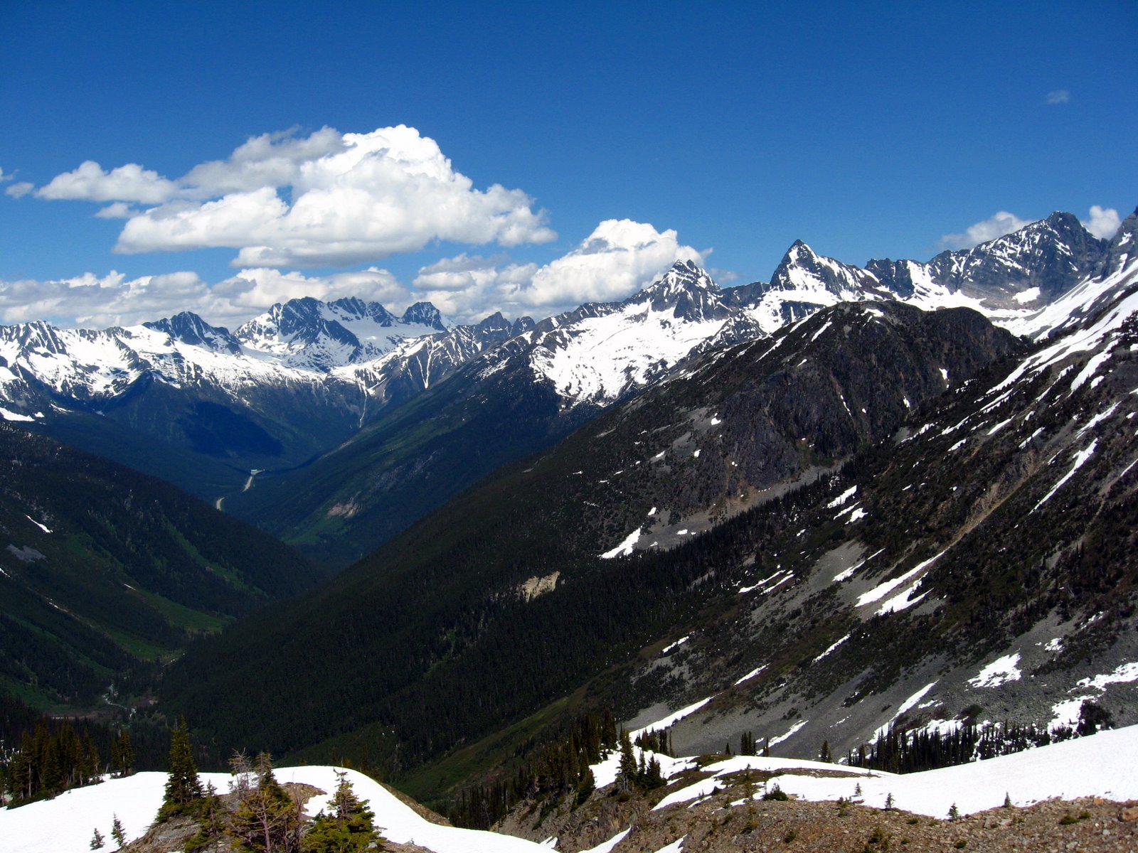
Six Days With the Sask Section
 Just finished helping out with the Sask Section's Mountaineering Camp, where we take (relative) beginners and start the process of helping them learn how to travel in the mountains safely.
This year, the camp was held at the Peter & Catharine Whyte (Peyto) Hut, the northern-most hut on the Wapta Icefield.
Because of a bridge issue on Peyto Creek (apparently out since last September and apparently not something Parks Canada wants to fix), our route in was via the Bow Hut.
Each day we held class sessions and traveled across the glacier to climb one of the nearby peaks. We had almost every kind of weather possible, from rain to 6" of new snow to solar furnace. From a distance, we could see the toe of the Peyto Glacier where there is now a lake and a steadily receding glacier. But we all know that climate change has nothing to do with that....
All in all, a good week with great participants and old friends.
Friday, July 08, 2011
Asulkan Pass for 24 hours
 One of my volunteer activities is with the Alpine Club and their hut maintenance projects. The past 2 days were spent in the Rogers Pass area at the Asulkan Hut, which is about a kilometer above Rogers Pass at the edge of the Asulkan Glacier. This is a decent summer hiking objective with numerous mountaineering opportunities in the area and a prime backcountry skiing destination in the winter. The Asulkan Hut was/is owned by Parks Canada, but the entire operation of the hut has been taken over by the ACC, hence this trip.
This trip was for the regular hut maintenance operations and also have a small volunteer group stain the hut, do some cleaning and carry out some other painting. Our group included one ACC staff person and 6 volunteers. After the helicopter carried up the season's propane tanks and finished some other duties, we were all flown up with our equipment. This was Thursday, with blue skies, warm temperatures and great views on the way up.
With the good weather, we set about the staining project right away and nearly had the hut completed by supper time. While we waited for supper to cook, we made a quick hike up to Asulkan Pass for the views over the other side. Skies were really black to the south and when we heard the thunder, we picked up the pace a bit, making it back to the hut before the storm hit.
It rained, blew and snowed most of the night, and the morning presented us with low cloud, fog and no view much beyond the nearest snowdrift. After a couple of hours of cleaning, I packed up and headed down the trail because I had to be home by supper. The others were staying until Saturday to finish some painting and other jobs. The snow at that elevation made for easy and quick downhill hiking, but one bridge was out at the bottom of the moraine. Fortunately there was a good snow bridge over one raging stream. Once I tip-toed over that, the rest of the hike out was quite decent, although there was lots of old avalanche debris - bits of trees, snow - for some distance.
By the time I got home, the sun was out.
The Kootenay Lake Millpond
 Summer arrived in earnest a few days ago so we decided to take one particularly hot, calm afternoon and canoe over to the other side of the Lake, absorb some infra-red radiation, generate some Vitamin D, have a little fire on the beach, roast some hot dogs and paddle back home.
This is a view back towards town from across the Lake. There are many days when this big lake is just like a millpond - a 60-mile-long lake of flat, calm water.
The east side of the Lake is very interesting to paddle along. Very interesting shoreline with very nice rock cliffs that you can get right next to. Our destination was Campbell Bay which we see regularly from the west side of the Lake but had never paddled over to see.
The paddle back across the Lake wasn't quite as calm since a small breeze had started, but nothing alarming.
Subscribe to:
Comments (Atom)