Wednesday, June 30, 2010

Exploring the Koots - 0630 - Mt Schroeder

Had a call from another hiking/skiing friend from town wanting to know if I was interested in climbing Mt Schroeder today. Decisions like these are always so difficult.....

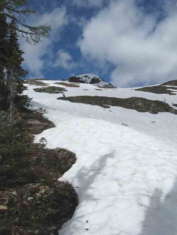
Bringing Catherine along just so she could experience the joys of Kootenay bushwhacking, we picked up Osa at 6 am and by 7 am had driven up the Schroeder Creek FSR and arrived at where we figured the hiking should begin. No trail up this mountain either, so it was another couple of hours slowly working our way up a steep ridge, climbing over fallen logs, pushing through alder, Devil's Club and rhododendron bushes. Finally we gained more open ground and only had a few moderate snow slopes and a brief scramble to the summit. Familiar peaks were visible in all directions.

Not really wanting to go downhill through all that brush, we decided to try an alternate route down some very steep snow slopes to a valley bottom that was very close to a logging road. Some of the going was tricky, but we only had a brief battle with the forest before we emerged on the road only a few km from the truck. We were home by mid-afternoon.

Some pictures are available at the end of the "Spring & Summer 2010" web album.

Monday, June 28, 2010

Exploring the Koots - 0627 - Mt Kaslo

Yesterday was a day to experience the best in West Kootenay bushwhacking as four of us set out to climb Mt Kaslo.

This is a moderate peak right across the lake from the town of the same name and my hiking partner and I have been looking at it for some time now, considering when we ought to go see what the summit was like.

As it turned out, there were 4 of us along to catch the 6:30 am ferry from Balfour to the east side of Kootenay Lake. By 8 am we had driven north up the Lake and east along another old logging road and were ready to start thrashing through the bush.

To make a long bushwhack story short, it took 7 hours of that kind of travel to get to the summit and back, each with our own personal cloud of mosquitoes following in our wakes. There is no trail up this mountain, so the strategy was to head off through the trees in the general direction. It's a pretty thick forest so views were pretty limited until we neared the top.

Views from the summit, though, were as to be expected - Mt Loki to the south, Powder Creek to the east, Kootenay Lake below us and mountains in all directions. After a rest and some sustenance, we began the thrash back down. It was shorter, but no more fun than the ascent. We just missed one ferry so had to console ourselves with ice-cream cones while waiting for the next boat to take us across the lake.

Tuesday, June 22, 2010

Given the Circumstances, What Else Can You Do?

With the oil "leak" in the Gulf continuing with no end in sight, irony (or possibly sarcasm) may be the only forms of humour suitable. Check out Wimp.com.

And that word? It's "Regulations". Apparently not a term Republicans were familiar with.


Monday, June 21, 2010

Exploring the Koots - 0620 - Krao Lake Revisited

Yesterday Stu and I hiked up to Krao Lake, a small body of water high above Ainsworth with a great view of Kootenay Lake. I'd been there a couple of times before, but we needed something relatively short and more suited for "training". And we were interested to know how much snow was still on the ground up high. Krao Lake is at about 6500 ft.

On the way up, we noticed how poor the road conditions were. This is a Forest Service Road and is being used by active logging, so that in itself wasn't so unusual, but it's also the access to Cody Caves Provincial Park. We weren't sure how many tourists would be able to visit the park given how rough the road was. I heard later that the Park will not likely open this year because of changes to Parks fees, road conditions and the like. Mostly to do with neglect on the part of our wonderful Provincial Government. Sigh.

Not far along from the trailhead, we were on snow, and by the time we arrived at the lake, there must have been at least 1.5 meters of the stuff on the ground. It was firm and easy walking, fortunately.

We picked a safe gully and climbed up to a peak above the lake to see the views. Sitting in the sun with Kootenay Lake below and mountain peaks in all directions makes one feel very fortunate to live in such a beautiful place.

Thursday, June 17, 2010

Better Late Than Never, I Suppose

The final report into the Air India mess was released today. Heck, it's only been a quarter of a century since it happened. So what have we learned?

Our National Security Forces (CSIS and the RCMP) bungled their investigation and weren't working together well enough to deal with information they had before the event. Not much has changed since then, apparently. Obviously, turf wars are more important than the safety of the public.

Airport and airline security is still missing the mark, as it was then.

What's likely to happen? Well, the report's 3000 pages will certainly be sitting on some dusty shelf in Ottawa. I can't imagine that any Canadian government will have the guts to deal with CSIS or the RCMP. It's also more likely that the traveling public will be subjected to more nonsense like removing their shoes and not being allowed to take baby bottles and small containers of water on board. Oh, and no toothpaste either and don't forget the total body scans. There, that should make everyone feel safer.

Friday, June 11, 2010

The G20 Boys - Increasingly Out of Touch

This is a picture of a real lake. It's a lake in BC, one of thousands and thousands in the province. Pretty lakes, impressive lakes. And although BC may be "The Best Place on Earth", even it doesn't have a monopoly on nice lakes. Canada is full of them. And check out the green stuff at the edge of the lake. That's real grass, not Astroturf.

So why, in all that's holy, does our federal "government" feel the need to spend any amount of money to create a fake lake surrounded by Astroturf in downtown Toronto, or whatever part of the center of the universe the G20 clowns are meeting in? I realize there is very little "nature" left in southern Ontario, but a fake lake, using taxpayers' money??? Have these goofs completely lost their marbles?

The so-called leaders of the G20 represent countries and governments that have accumulated massive national debts and generally mismanaged things so badly that the world's economy is closer to meltdown than we want to imagine. Hosting this bunch at our expense and supporting the media circus that seems to go with such meetings, with a security cost exceeding $1 billion? Words almost fail me.

Fortunately I have just enough words left to remind everyone that this is a minority government that simply just doesn't "get it". They don't seem to understand the term "fiscal prudence", they don't understand environmental issues or human rights concerns. This G20 spending debacle is simply the latest in a string of disasters from Harper and his gang. It's time for them to go.

Sunday, June 06, 2010

On the Gold Rush Trail

We just finished a short trip further west in BC, exploring some of the early Gold Rush Trail. The main objective was to get to Lillooet and do some exploring around that area. And since the weather at home didn't seem to be shaping up to be very summer-like, we decided to head out.

Our first stop was just north of Rock Creek in a nice BC Provincial Park with a campsite right on Rock Creek. This is one of the Trans Canada Trail access points, so we did a bit of walking and trying to figure out what birds were chirping in the trees. One nice thing about camping at this time of year (and in mid-week) is that the campgrounds are still pretty empty.

The next day we made it through Kelowna and on to Merritt. We've been past Merritt many times, but we couldn't recall ever actually going through the town, and our route took us through Merritt and on to Spence's Bridge. We camped for the night just south of there at another nice BC Provincial Park Campground. Part of our entertainment was watching the CP and CN trains roll up and down the canyon just below the campground. There was also a short hike that followed an old gold rush trail dating back to the late 1800s.

The next day we were on to Lytton, where the Fraser and Thompson Rivers join, and on to Lillooet, former home of "Ma" Murray and staging point for some of the Cariboo Gold Rush.

Lillooet wasn't all that interesting, although it has a nice setting, located on the Fraser River, nestled down between some pretty imposing peaks. This is one of the hottest places in Canada, and you could see why.

We spent a few hours driving over the Duffy Lake Road to Pemberton, which seemed much like a junior version of Canmore or Banff or something - all new condos and little shops. Exploring this didn't take much time so we headed back to a nice Forest Service campground on Cayoosh Creek.

The next day we spent some time in Lillooet, then headed north and east to Cache Creek, on to Kamloops and towards Vernon.

En route, we stopped briefly at the old farm that Catherine's parents once owned, continuing on to a quiet place on the Shuswap River for the night.

Our last few hours before getting home was spent going over Monashee Pass, taking a look at Edgewater, wandering around the lakeshore promenades and botanical gardens in Nakusp and New Denver, before completing the last short drive back to the hacienda.